MECCMap
In-vehicle GIS mapping application for first responders designed to quickly search and locate the address of an emergency
Overview
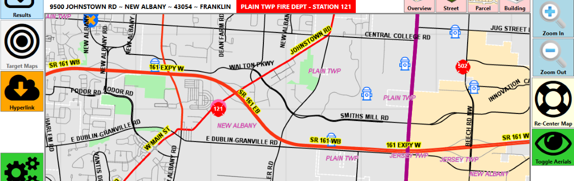
MECCMap is a Windows based, touch-screen GIS mapping applications designed for use in first responder vehicles to quickly locate the address or intersection of an emergency. The program is self-contained, meaning you don't have to rely on an internet connection for it to work. It's also designed to be easy to use, with searches using only a couple of letters of the street name rather than having to spell it all out. You can also attach "Target Maps" (think Pre-plans) to an address or group of address to have easy access to critical information. For counties which are set up to do so, you can also bring up a link to the parcel information from the auditors website and display it with one click.
GIS Data
MECCMap uses GIS data to display the map information. GIS Data is usually available from either your county or city GIS department (Auditor’s Office, Engineer’s Office, etc.) As part of the MECCMap subscription, we will take your locally available GIS data and tweak it to work best with MECCMap. Below is a list of data layers that MECCMap generally uses, and although only 2 are absolutely required, the more information you have available, the better.
- Address Points (required)
- Centerlines (required)
- Parcels
- Building Footprints
- Fire Departments
- Hospitals
- Hydrants / Dry Hydrants
- Water Mains / Shutoff Valves
- Hydrology
- Railroads
- Municipalities
- ZipCodes
- County Boundary
- Orthophotography
Pricing
Pricing for MECCMap is based on an annual subscription model for an entire department, rather than “per-computer.” When your department purchases a subscription, you are free to load MECCMap on all computers associated with your department, including station and truck computers, and also firefighters personal computers/laptops, if desired.
- Annual budget between $0 -> $100,000 – Price is $0 per year (no charge)
- Annual budget between $100,001 -> $350,000 – Price is $300 per year
- Annual budget between $350,001 -> $750,000 – Price is $480 per year
- Annual budget between $750,001 -> $2,000,000 – Price is $720 per year
- Annual budget between $2,000,001 -> $6,000,000 – Price is $960 per year
- Annual budget between $6,000,001 -> $15,000,000 – Price is $1,440 per year
- Annual budget above $15,000,001 – Price is $1,920 per year
System Requirements
Right now MECCMap is a Windows-only application. Pretty much any Windows 7 or later machine (desktop/laptop/tablet) will run MECCMap. A touch-screen monitor is recommended, but by no means required. Internet connection is recommended for viewing ortho-photography (think satellite view), but the program does not need an internet connection to search for addresses/intersections.